![]() All aboard the bus tour through Southowram starting at the bottom of Beacon Hill road towards Bank Top.
All aboard the bus tour through Southowram starting at the bottom of Beacon Hill road towards Bank Top.
Bus coming back down Beacon Hill Road
Heading up Beacon Hill Road - landslide
Looking down Old Bank
Near the bottom of Old Bank
Nicholls shop at the end of Blaithroyd Lane
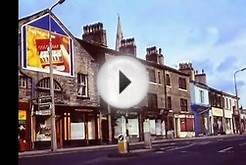
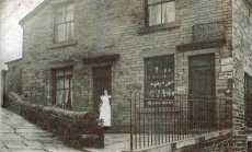
Apparently this is Battinson Street. Does anyone recognise the girl?
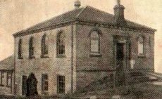
Bethesda Chapel. This was just below the Manor House pub.
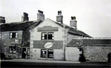
Never forgotten.
Personally, I had some of my lifetime favourite memories here with a really good crowd of regulars. This was when Pat and Kev had the pub and it never seemed to close. All that remains today is the bar signpost.
Remember the race back from town on a Sunday night before the doors closed?
Sunday morning football was a sight for sore eyes. Not really surprising that we lost by big margins after big drinks marathons. Even after getting thrashed, you wouldn't believe we had lost if you ever witnessed our Sunday afternoon/night shenanigans.
 Can you name some players from that era?
Who remembers the pre Pat/and Kev days?
This is looking towards Bank Top in 1901 and to the right of the picture is the Cock and Bottle pub(below). The visible pub was the Blue Bell that burned down.
Zion Sunday School opposite the Cock and Bottle pub.
Looking towards Bank Top from the bottom of Broadway
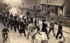
Anyone know why they are marching?
This is Law Hill School where Emily Bronte taught for 6 months.
Pinnar Lane once had an observatory.which stood around the Highfield farm area.
 World war 2 army camp on Law Lane
The 'Who Could A' Thowt It' Pub
Coming from town, before you get to Withinfields school this would be down the road to the left of the bend (waterclough lane).
Now a warehouse but once the Co-op stores or Halifax Industrial Society as the sign says. Positioned opposite what was the Pack Horse.
thanks to Jenny McGall for this picture
This is an old view of Southowram village. Just left of centre is the Pack Horse junction.
Some big differences are the lack of houses where Charles Avenue etc. now exists.
There are no buildings where the library and shops now exists.
There is a farm facing the Pack Horse at the bottom of Pinnar Lane
Social Club
Towngate in the 1950s. Richardsons Row are the terraced houses on the right but can anyone tell us what the other buildings are? There were several shops around this area at one time.
 Southowram stocks
The corner of West Lane.
Opposite the garage on the corner of West Lane where haulage company Lincoln Shackleton & Sons used to work from. They often used to deliver stone for Marshalls.
S Marshall quarry
Ashday Lane Sunday School formerly known as Heald Lane. Further down Ashday Lane, where the cricket ground now stands, used to be the workhouse. There was also a row of terraced houses past the ground.
Ashday Lane with Inghams sausage factory which is now Grange Heights
Ashday Hall
Ashday Hall
Looking up Caine Lane- still very recognisable
St Annes in the Grove 1908
St.Annes church can be seen in the background
This is just about opposite the Malt Shovel going towards Brighouse. What year would this have been?
Barker Royd Farm and Mill off the main road behind what was the Malt Shovel
Cote Hill
Marshalls Quarry
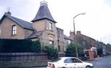
This is a recent photograph and as you can see, the pub name (Delvers Arms) is still visible.
Bottom of Brookfoot looking up at the Neptune Inn
The notorious Brookfoot Hill. Many a wagon driver has had a tale to tell about this hill.