Nova Scotia is no more than 130 km (87 miles) wide at any point, thus the sea plays a major role in the lives of its people. Nova Scotia's indigenous Algonquian people had been living off the area's bountiful waters for thousands of years before the first European explorers began their navigation and exploration.
Though Vikings may have been the first Europeans to set foot on Nova Scotia's soil, the first recorded exploration was made by English explorer John Cabot in 1497. Port-Royal, the first European agricultural settlement on land which is now Canadian was established over a century later in 1605 by Frenchmen Pierre Dugua, Sieur de Mons and Samuel de Champlain. In 1621 King James I of England changed the area's name from Acadia to Nova Scotia.
Nova Scotia Joins Canada
Throughout the 17th century the English and French fought for control of Nova Scotia with its vast natural resources and as a strategic naval and military location. Finally, in 1713, The Peace of Utrecht gave the British control of Nova Scotia, although France retained Cape Breton Island and Prince Edward Island.
By the 1860s, unification of all the Canadian provinces was being proposed. Though there was some opposition to joining the Union, Nova Scotia's Premier, Sir Charles Tupper, agreed to the terms of the Quebec Conference of 1864 and Nova Scotia entered the Dominion of Canada three years later in 1867.
Economic Boom and Bust
Trade and industry faltered after the American Civil War concluded in 1865 and many Nova Scotians emigrated from the area. During World Wars I and II, Nova Scotia provided many war materials and became a chief transit point for shipping munitions and other supplies to Western Europe, providing a substantial boost to the economy.
Nova Scotia Today
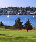 Throughout the history of Nova Scotia, the sea has played an integral role and continues to do so today. With 3, 809 coastal islands and 7, 579 km (4, 709 miles) of shoreline ranging from rugged and rocky headlands to serene harbors, water is at the heart of this picturesque landscape. Nova Scotia is also home to the Bay of Fundy, renowned for having the world's highest tides and a finalist for the New 7 Wonders of Nature.
The province is bordered to the west by New Brunswick and the state of Maine in the U.S., with Prince Edward Island and Newfoundland to the north.
Nova Scotia's population is over 940, 000 and its capital city of Halifax is the economic hub of the region. Nova Scotia has traditionally had a wealth of natural resources, but has diversified its economy since the end of WWII.
New industries, including tourism, technology and finance have joined mainstays such as mining, fishing, agriculture and forestry giving Nova Scotia one of the fastest growing economies in Canada. The Halifax area is also one of Canada's most attractive places to live with above average family incomes and highly affordable real estate.