 Late Friday afternoon update.
We took amounts up across parts of central and eastern Nova Scotia as the storm is a little more intense and the track is very favorable for all out blizzard conditions from east of New Glasgow through all of Cape Breton through this evening. Some sleet may mix in briefly along the south coast of Nova Scotia, but this is looking more snowy at this time, so we still may be a bit underdone with snowfall from Halifax on northeast along the coast.
Previous.
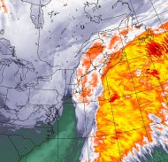
Storm currently southeast of New England and steadily intensifying.
Latest surface, satellite, radar and model trends continue to point toward a slightly more northern track with this storm which means we have to take amounts up in southeastern New Brunswick, PEI and northern Nova Scotia and also expand the heaviest snow farther north/west over Newfoundland. A period of mixed precipitation will limit snowfall along the south-central/southeast coast of Nova Scotia, while the combination of warming and a significant dry slot will quickly shut down the accumulating snow tonight over the Avalon Peninsula, especially the southern half.
Still looking at blizzard conditions with this storm from northeast Nova Scotia through central Newfoundland.
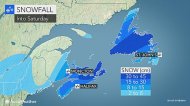
 Updated snowfall forecast map (late Friday morning).
Just finished putting together the snowfall forecast map below.
Northward trend with the storm track continued last night as the two streams of energy will merge earlier than what was shown a few days ago. This allows the coastal storm to get drawn farther north and intensify more quickly.
The farther northward track will also allow milder air to get drawn into the south-central coast of Nova Scotia for a few hours Friday afternoon leading to some mixed precipitation before going back over to snow. If it does stay all snow in Halifax, NS, then the city may end up with 15-20 cm. Clearly, the worst of this storm for the Maritimes will be across northeastern Nova Scotia with blizzard conditions Friday evening and night, especially across Cape Breton. Localized snowfall approaching 35-45 cm with significant drifts. If you are looking for extreme weather, you will find it in the Cape Breton Highlands!
Most of the snow accumulation that you see from central New Brunswick on west is more associated with the weakening clipper storm over Quebec. The more northern track will also send moderate snow into the central and eastern part of PEI Friday and Friday evening.
In Newfoundland, confidence has increased that the storm center will track across the Avalon Peninsula Saturday morning, which is not a favorable track for heavy snow accumulations in that area. What this means is that there will be several hours of moderate to heavy snow across the Avalon Peninsula from late Friday afternoon into the evening before it changes to sleet/ice and then possibly rain (mainly south coast) before ending late at night as the dry slot sweeps in. Farther north and west, a blizzard will rage Friday night into midday Saturday in places such as Gander and Bonavista.