 ***You can find the weekly long-range update on the previous post from Friday.
Friday afternoon update
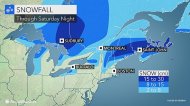
Just slight changes to the snow map. Some of the accumulation in the Halifax, NS, area includes sleet.
Core of highest snowfall still looks to be southern New Brunswick and the northern third of Nova Scotia.
Friday morning update
More concerned about more mixing and rain from coastal Maine through the southern half of Nova Scotia with the storm Saturday as it will be tracking a little closer to the coast than what we thought yesterday and the fact that there is no cold high in the way of this storm so that any cold will quickly get pushed out in these areas on Saturday.
We these ideas in mind, we have trimmed amounts from southern New Hampshire and coastal Maine through the southern third of Nova Scotia.
Based on the current thinking we believe that the axis of heaviest snow will be from just northwest of Eastport, ME to just north of Saint John, NB and across northern Nova Scotia.
Again, this storm will be moving along and not stalling, and that is the primary reason for not including a 30-45 cm area.
Northeast shifting to north winds Saturday afternoon and night could gust to 85 km/h along the coastal Maritimes, but it appears that the core of the real strong winds will remain offshore with this particular storm.
Thursday afternoon update.
Latest forecast modeling continues to keep the energy from the two storm systems basically separate for Saturday and Saturday night, which in turn allows the coastal storm to track a little farther south/east and move more quickly, which we think will result in less snow than what we originally thought for places such as northern/eastern New Brunswick. Farther west, the combination of cold air, higher terrain and an inverted trough should allow for a significant accumulation over interior Maine and into the White Mountains of New Hampshire.
If the energy phased then the coastal storm ends up stronger, moves slower and gets drawn farther north, resulting in higher snowfall across central and northern New Brunswick and PEI. However, the trends have been going away from that idea.
Since the energy will remain split there ends up being an area where there will be less than favorable dynamics for snow and that appears to be the St. Lawrence River Valley.
On the other hand, the shift in the track will send the heavier snowfall slightly farther south and across a large portion Nova Scotia and extreme southern New Brunswick. While we cannot rule out a few spots getting a little more than 30 cm in this area, the bulk of the area should end up with 15-30 cm as the storm is going to be moving along and not stalling. Right now, we have the Halifax, NS area near the 15 cm line, but if latest trends continue we will likely have to bump that up a bit.
Still feel there can be some mixing along the south coast of Nova Scotia and temperatures may end up just a little too warm for any accumulating snow over the extreme southern point of Nova Scotia.
Since the storm will not be phasing with the northern energy it will continue to track more east than northeast Saturday night and thus the best chance for accumulating snow in Newfoundland will occur over southeastern Newfoundland. At this point, I can see a general 8-15 cm of snow from the Marystown area and points south over to the southern Avalon Peninsula Saturday night and early Sunday. St. John's looking more like 2-8 cm at this point, but a slight shift in the track could easily change that.
Previous post from Thursday morning...
In the middle of my schedule right now, so this will be short. Computer models currently delaying the phasing of energy Friday night and Saturday over eastern Canada and the northeast U.S. which lessens the chance of a real big storm for Maine and the Maritimes as the energy remains too split. There will still be an intensifying storm tracking just off the coast, but it will be moving more quickly as the heavy precipitation shield will not be as expansive. The delayed phasing will also prevent colder air from getting drawn into the coastal storm such that we may be dealing with mixed precipitation from coastal Maine through at least the southern two-thirds of Nova Scotia, which would cut down amounts. Still, we believe there will be a significant accumulation of snow from northern Maine through New Brunswick, PEI and northern Nova Scotia, but not the crippling type.
The snow map that we drew up this morning will almost certainly change as we get more information and I suspect that the 15-30 cm area will eventually shrink somewhat across the Maritimes and possibly Maine as we will be able to better pinpoint the region for heaviest snowfall on Saturday.
**Any change in the track and strength of the coastal storm will have a big impact on the total snowfall and precipitation type.
Farther west, confidence is higher for a significant snowfall with the primary low over northern Ontario and western Quebec.
Behind the primary low there will be lake-effect snow downwind of the lakes Saturday into Saturday night before another clipper storm dives in from the west on Sunday followed by the next Arctic blast.


